In India’s vast but fragmented agricultural landscape, where livelihoods tilt with the monsoon winds, water is both lifeline and gamble. Riddhish Soni set out to change this through Aumsat Technologies, with tools forged for space exploration turned towards the Earth.
Using radar, remote sensing and technologies that can detect resources under the surface of heavenly bodies, Aumsat detects groundwater resources more accurately to help farmers make better decisions. It also identifies leakages in buried pipeline networks – a dangerous and not infrequent source of water loss and contamination in India.
In both use cases, the goal is the same, Soni says – remove guesswork, and replace it with data-backed insight.
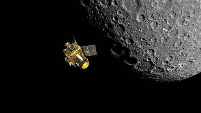
When Riddhish Soni was working as a scientist with ISRO on the Chandrayaan-2 lunar mission, the team was engaged in the search for water on the Moon. While water was first detected in 1994 by the radar instrument aboard the US satellite Clementine and later validated by India’s Chandrayaan-1 mission in 2009, this experience sparked a transformative question for Soni: If advanced radar and spectral technologies could detect water signatures on the Moon, why couldn’t similar Earth observation technologies be used to discover, prospect and target underground water resources in drought-prone regions of India? That question became the founding insight behind Aumsat.
Making the invisible, visible
“Growing up, I witnessed how access to water could determine agricultural outcomes, household security and even migration patterns,” says Soni, 35, of his childhood in Jamnagar, Gujarat. “These experiences created an early sensitivity to resource scarcity, long before I entered the scientific domain.”
Academically and later professionally, he underwent training in space science and remote sensing, culminating in his work as a scientist at the Indian Space Research Organisation (ISRO), where he was part of missions such as Chandrayaan-2. His work involved the use of advanced radar and thermophysical instrumentation for detecting the presence of water and other critical elements under the moon’s surface.
“This exposure shaped how I think about complex systems – whether they exist on the Moon or beneath the Earth’s surface,” he says, adding that he was inspired by the power of science to make the invisible, visible.
While technology was detecting subtle signatures of water, minerals and heat beneath layers of regolith – the loose surface material above a planet’s bedrock – on Earth, water authorities across the country were making decisions through trial-and-error, intuition or legacy practices. “This contrast was both striking and uncomfortable,” Soni said.
This contrast, and the intersection of science and real-world challenges, gave birth to Aumsat Technologies in the year 2019, when Riddhish, along with co-founder Chetan Soni, began developing satellite data applications focused on groundwater targeting, recharge planning, irrigation intelligence, and long-term water sustainability. What began as scientific curiosity evolved into a mission-driven enterprise – translating space-grade detection capabilities into actionable hydro-informatics solutions on Earth.
Aumsat, in Soni’s words, was built at the convergence of geomatics, predictive analytics, radar remote sensing, object detection, statistical modelling, and AI-driven geospatial intelligence. This veritable collection of technologies together forms a kind of planetary nervous system, and is becoming increasingly useful in infrastructure monitoring, climate risk analysis, environmental protection and so on. The founding team assembled multidisciplinary experts who moved beyond theoretical research into field-deployable systems for water targeting, monitoring, and prospecting, thereby laying the foundation for a smart, data-driven water management ecosystem in India.
How it all came together
Space missions had already validated the use of radar-based remote sensing, particularly radar polarimetry and interferometry, to detect subsurface resources. The idea that space-grade technologies could be repurposed to solve terrestrial problems, particularly water scarcity, became Soni’s mission.
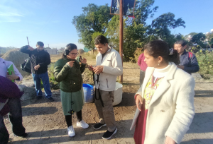
A capacity-building workshop for government water supply engineers. Photo by Aumsat Technologies
Across rural India, many farmers spend large portions of their savings on borewells, even though fewer than 30% succeed. In cities, utilities lose 30 to 50% of treated water as “non-revenue water” that disappears through leaks and is never paid for. These losses are often invisible and usually fixed only after major failures occur, Soni says.
Climate change makes the situation worse. Rainfall patterns are shifting, droughts and floods are becoming more frequent, and groundwater levels are falling. Old assumptions no longer hold, and decisionmakers – whether farmers, engineers or policymakers – need real-time, evidence-based information instead of outdated maps and static reports.
Water policy and infrastructure planning are key areas where Aumsat can help. Water systems are often expanded without leak audits, aquifer stress checks or subsurface analysis. This leads to repeated spending without solving the underlying problem. As Soni explains, Aumsat was built as a decision-support tool to guide policy, investment and governance.
Aumsat also benefited from a supportive entrepreneurial ecosystem. Early pilot projects with farmers, public utilities and later international clients helped test both the technology and the business model. These early results showed that satellite-based subsurface intelligence can deliver practical benefits and be economically viable.
Scaling science
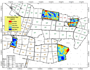
An example of a groundwater map. Photo courtesy Aumsat Technologies
Bringing space science to India’s farms and cities has not been easy. Agriculture is fragmented, with mixed crops and heavy dependence on the monsoon making standard solutions ineffective.
“Many farms are less than two hectares, often irregular in shape and interspersed with different crops and irrigation practices. This makes it difficult to apply coarse-resolution satellite products or generic advisories,” Soni explains, “High-resolution data and hyper-local interpretation are essential, but such data is often expensive, temporally sparse or difficult to integrate operationally at scale.”
Farmers often drill borewells without clear knowledge of their aquifers. Most remote sensing tracks surface changes, leaving subsurface water largely unseen. There is also a trust gap. Many farmers have tried advisory systems that did not deliver, so science must prove itself on the ground.
Climate change adds more uncertainty. Rainfall is erratic, dry spells are longer, and old patterns no longer guide decisions.
Using advanced L band satellite radar, which can penetrate deeper below the ground and built structures than conventional imagery – without disturbing the terrain – makes it possible to identify slow leaks, groundwater movement, subsidence and stress zones that would otherwise remain invisible.
Soni says the real value is not just the images, but how they are used: “For a farmer, this may mean identifying the most sustainable zone to drill a borewell. For a water utility, it could mean prioritizing sections of a pipeline network for inspection before catastrophic failure occurs. The emphasis is always on prediction and prevention rather than post-failure response.”
Tech alone isn’t enough
Technology, however, is only one piece of the story. Soni is candid about the systemic barriers that slow progress: fragmented policies, misaligned incentives, reactive infrastructure management and siloed data systems. Water-intensive crops are often incentivized in groundwater-stressed regions. Pipelines are laid without prior diagnostics. Data exists, but remains inaccessible or inconsistent. And behavioural resistance is real.
What this means is that sustainable water management needs technology, yes, but also policy reform, institutional coordination, data transparency and sustained engagement with end users.
Building such systems requires patient capital. Satellite analytics and radar physics demand long development cycles and rigorous validation. “This is because they operate at the intersection of technology, climate science and public infrastructure. Unlike conventional start-ups, the value created lies in long-term impact – an attribute not always aligned with short-term return expectations.”
To navigate this, Soni has focused on building intellectual property: the company holds 24 patents. It follows a hybrid model where research continues alongside revenue-generating deployments with farmers, utilities, smart cities and international clients.
“This [has] allowed us to maintain operational cash flow while continuing to invest in R&D, rather than relying entirely on external capital. Government and utility-led projects, in particular, have helped us validate our solutions at scale, creating stable revenue,” Soni says.
From projects to platforms
For Soni, water security and climate resilience cannot be solved piecemeal. “They require systemic transformation, driven by science, data, and long-term institutional adoption,” he says.
In the near term, the focus is on improving pipeline leak detection accuracy from 78% to 95%. Expansion across additional Indian states is underway, along with efforts to digitise pipeline networks and groundwater assets.
Over the next few years, the goal is to move from individual projects to platform-level adoption, helping governments convert non-revenue water into revenue water and strengthening financial sustainability without increasing extraction.
International expansion across South and Southeast Asia, the Middle East and other climate-vulnerable regions is also part of the plan. “International deployments are essential for stress-testing technology and demonstrating its relevance in diverse environmental and policy contexts,” Soni says.
At its broadest level, Soni wants to change how water is perceived: from invisible and taken for granted to measurable, monitorable and accountable.
“If, in the coming years, fewer borewells fail, fewer pipelines leak are unnoticed, and fewer communities face avoidable water crises because decisions were informed by evidence rather than assumption, we will consider our mission successful,” he says.
An independent writer, Sapna Gopal has been covering the renewable energy and environment sector since 2009.
Inspired to Take Action?
Tl;dr: A summary for the busy, the curious, and the done-for-today
Founded by former ISRO scientist Riddhish Soni, the startup repurposes radar and remote sensing (used in missions like Chandrayaan-2) to detect groundwater and pipeline leaks on Earth.
Its technology provides data-driven insights on subsurface water, helping farmers identify viable borewell locations and utilities detect hidden leakages – reducing guesswork and losses.
In India, many borewells fail and up to 30-50% of urban water is lost through leaks, worsened by climate change and outdated decision-making tools – creating strong demand for real-time, evidence-based solutions.
Adoption is slowed by fragmented landholdings, high cost of high-resolution data, trust gaps among farmers, and systemic issues like weak policy coordination, siloed data and misaligned incentives.
With patents, pilot success and a hybrid revenue model, Aumsat aims to scale into a platform for water governance – improving leak detection, guiding policy and expanding globally to build climate-resilient water systems.